


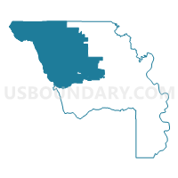
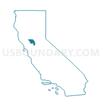
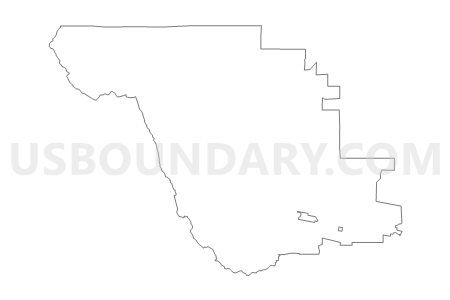
Voting District 50355, Yolo County, California
About
Outline

Summary
| Unique Area Identifier | 546118 |
| Name | Voting District 50355 |
| County | Yolo County |
| State | California |
| Area (square miles) | 336.82 |
| Land Area (square miles) | 335.98 |
| Water Area (square miles) | 0.84 |
| % of Land Area | 99.75 |
| % of Water Area | 0.25 |
| Latitude of the Internal Point | 38.83447020 |
| Longtitude of the Internal Point | -122.12716510 |
Maps

Graphs
Select a template below for downloading or customizing gragh for Voting District 50355, Yolo County, California


Neighbors
Neighoring Voting District (by Name) Neighboring Voting District on the Map
- Voting District 10010, Lake County, CA
- Voting District 19000, Colusa County, CA
- Voting District 20050, Lake County, CA
- Voting District 30230, Napa County, CA
- Voting District 39035, Colusa County, CA
- Voting District 39040, Colusa County, CA
- Voting District 50250, Yolo County, CA
- Voting District 50265, Yolo County, CA
- Voting District 50335, Yolo County, CA
- Voting District 50340, Yolo County, CA
- Voting District 50345, Yolo County, CA
- Voting District 50350, Yolo County, CA
- Voting District 50370, Yolo County, CA
- Voting District 50385, Yolo County, CA
- Voting District 50390, Yolo County, CA
Top 10 Neighboring County Subdivision (by Population) Neighboring County Subdivision on the Map
- Woodland CCD, Yolo County, CA (58,695)
- Clearlake CCD, Lake County, CA (15,849)
- Central Colusa CCD, Colusa County, CA (11,838)
- Winters CCD, Yolo County, CA (8,106)
- Esparto CCD, Yolo County, CA (5,325)
- Knights Landing CCD, Yolo County, CA (4,193)
- Lower Lake CCD, Lake County, CA (3,198)
- Lake Berryessa CCD, Napa County, CA (1,806)
- West Colusa CCD, Colusa County, CA (783)
Top 10 Neighboring Place (by Population) Neighboring Place on the Map
Top 10 Neighboring Unified School District (by Population) Neighboring Unified School District on the Map
- Woodland Joint Unified School District, CA (61,413)
- Konocti Unified School District, CA (22,639)
- St. Helena Unified School District, CA (9,714)
- Pierce Joint Unified School District, CA (6,804)
- Williams Unified School District, CA (5,976)
- Esparto Unified School District, CA (5,931)
Top 10 Neighboring State Legislative District Lower Chamber (by Population) Neighboring State Legislative District Lower Chamber on the Map
- Assembly District 2, CA (469,582)
- Assembly District 7, CA (453,345)
- Assembly District 1, CA (443,842)
Top 10 Neighboring State Legislative District Upper Chamber (by Population) Neighboring State Legislative District Upper Chamber on the Map
- State Senate District 5, CA (1,032,613)
- State Senate District 4, CA (988,287)
- State Senate District 2, CA (897,433)
Top 10 Neighboring 111th Congressional District (by Population) Neighboring 111th Congressional District on the Map
Top 10 Neighboring Census Tract (by Population) Neighboring Census Tract on the Map
- Census Tract 113, Yolo County, CA (8,106)
- Census Tract 112.06, Yolo County, CA (7,329)
- Census Tract 3, Colusa County, CA (6,055)
- Census Tract 115, Yolo County, CA (5,325)
- Census Tract 1, Colusa County, CA (5,183)
- Census Tract 114, Yolo County, CA (4,193)
- Census Tract 7.02, Lake County, CA (4,029)
- Census Tract 12, Lake County, CA (3,198)
- Census Tract 2018, Napa County, CA (1,806)
Top 10 Neighboring 5-Digit ZIP Code Tabulation Area (by Population) Neighboring 5-Digit ZIP Code Tabulation Area on the Map
- 94558, CA (66,830)
- 95695, CA (37,946)
- 95694, CA (9,156)
- 95987, CA (5,992)
- 95912, CA (4,685)
- 95627, CA (3,513)
- 95457, CA (2,893)
- 95937, CA (1,491)
- 94567, CA (623)
- 95653, CA (527)